Difference between revisions of "Download"
From The GenGIS wiki
Jump to navigationJump to search| Line 53: | Line 53: | ||
=== GenGIS Source Code === | === GenGIS Source Code === | ||
| − | Source code is for v2. | + | Source code is for v2.01. GenGIS dependencies are given in /src/Readme.txt. |
| − | *[[Media:GenGIS_v2. | + | *[[Media:GenGIS_v2.01_source.zip|Source code package (~4.2 MB)]] |
=== Previous Versions === | === Previous Versions === | ||
Revision as of 18:40, 30 April 2012

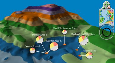
Abundance of different taxa at sample sites from the Sydney Tar Ponds (data courtesy of Jeremy Koenig)
Currently we support Microsoft Windows XP/Vista/7 and Mac OS X (Intel only). GenGIS is released under the GNU General Public License version 3.
Contents
Current Release Details
| GenGIS Version: | 2.0.1 (April 30, 2012) |
|---|---|
| Python Version: | 2.6.1 for Windows, 2.5 for Mac |
| RPy2 Version: | 2.0.3 |
| wxWidgets Version: | 2.8.9 |
Revision History | Known Issues
Windows Release
- Windows installation package (XP/Vista/7) (47 MB)
Mac OS X Release
- Mac OS X installation package (10.5-7, Intel Only) (167 MB)
MapMaker
- Download MapMaker to obtain maps compatible with GenGIS.
Sample Data
Sample data can be found on the Tutorials page.
Digital Maps
You can use our tool MapMaker to generate high-resolution GeoTIFF for any region in the world. Instruction on obtaining digital terrain maps (DEMs) are provided on the Tutorials page. We have also assembled a collection of example digital terrain maps:
- Sample world map (GeoTIFF, from GTOPO30)
- Africa (GeoTIFF, from GTOPO30)
- Europe (ASCII grid, from GTOPO30)
- South Pacific (ASCII grid, from GTOPO30, spanning example with longitude 0-360)
- South Pacific Reduced (ASCII grid, from GTOPO30, spanning example with longitude 0-360)
GenGIS Source Code
Source code is for v2.01. GenGIS dependencies are given in /src/Readme.txt.
Previous Versions
- GenGIS v2.00 (Windows | Mac)
- GenGIS v1.08