|
|
| Line 17: |
Line 17: |
| | | | |
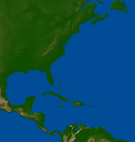
| | [[Image:NorthAtlantic.jpg|frame|Map of North Atlantic Seaboard from 100W50N to 50W5N.|center]] | | [[Image:NorthAtlantic.jpg|frame|Map of North Atlantic Seaboard from 100W50N to 50W5N.|center]] |
| − |
| |
| − | <html>
| |
| − | <head>
| |
| − | <!-- saved from url=(0025)http://www.techsmith.com/ -->
| |
| − | <meta http-equiv="Content-Type" content="text/html; charset=UTF-8" />
| |
| − | <meta name="DC.title" content="H1N1_SwineFlu_Spread" />
| |
| − | <meta name="DC.date" content="2009-05-21 04:19:41 PM" />
| |
| − | <meta name="DC.language" content="ENU" />
| |
| − | <meta name="DC.subject" content="Influenza" />
| |
| − | <meta name="itunes.keywords" content="Influenza, H1N1, Swine Flu" />
| |
| − | <meta name="DC.description" content="Geographic visualizations built using GenGIS (http://kiwi.cs.dal.ca/GenGIS) Automated data retrieval and tree construction: Norm MacDonald GenGIS visualizations and data handling: Donovan Parks Mike Porter Suwen Wang The development of GenGIS wa" />
| |
| − |
| |
| − | <title>Created by Camtasia Studio 6</title>
| |
| − | <script type="text/javascript" src="swfobject.js"></script>
| |
| − | <script type="text/javascript">
| |
| − | swfobject.registerObject("csSWF", "8", "expressInstall.swf");
| |
| − | </script>
| |
| − | <style type="text/css">
| |
| − | body
| |
| − | {
| |
| − | background-color: #1a1a1a;
| |
| − | font: .8em/1.3em verdana,arial,helvetica,sans-serif;
| |
| − | text-align: center;
| |
| − | }
| |
| − | #media
| |
| − | {
| |
| − | margin-top: 40px;
| |
| − | }
| |
| − | #noUpdate
| |
| − | {
| |
| − | margin: 0 auto;
| |
| − | font-family:Arial, Helvetica, sans-serif;
| |
| − | font-size: x-small;
| |
| − | color: #cccccc;
| |
| − | text-align: left;
| |
| − | width: 210px;
| |
| − | height: 200px;
| |
| − | padding: 40px;
| |
| − | }
| |
| − | </style>
| |
| − | </head>
| |
| − | <body>
| |
| − | <div id="media">
| |
| − | <object classid="clsid:D27CDB6E-AE6D-11cf-96B8-444553540000" width="768" height="514" id="csSWF">
| |
| − | <param name="movie" value="H1N1_SwineFlu_Spread.swf" />
| |
| − | <param name="quality" value="best" />
| |
| − | <param name="bgcolor" value="#1a1a1a" />
| |
| − | <param name="allowfullscreen" value="false" />
| |
| − | <param name="scale" value="noscale" />
| |
| − | <param name="allowscriptaccess" value="always" />
| |
| − | <param name="flashvars" value="autostart=false&color=0x1A1A1A,0x1A1A1A" />
| |
| − | <!--[if !IE]>-->
| |
| − | <object type="application/x-shockwave-flash" data="H1N1_SwineFlu_Spread.swf" width="768" height="514">
| |
| − | <param name="quality" value="best" />
| |
| − | <param name="bgcolor" value="#1a1a1a" />
| |
| − | <param name="allowfullscreen" value="false" />
| |
| − | <param name="scale" value="noscale" />
| |
| − | <param name="allowscriptaccess" value="always" />
| |
| − | <param name="flashvars" value="autostart=false&color=0x1A1A1A,0x1A1A1A" />
| |
| − | <!--<![endif]-->
| |
| − | <div id="noUpdate">
| |
| − | <p>The Camtasia Studio video content presented here requires a more recent version of the Adobe Flash Player. If you are you using a browser with JavaScript disabled please enable it now. Otherwise, please update your version of the free Flash Player by <a href="http://www.adobe.com/go/getflashplayer">downloading here</a>.</p>
| |
| − | </div>
| |
| − | <!--[if !IE]>-->
| |
| − | </object>
| |
| − | <!--<![endif]-->
| |
| − | </object>
| |
| − | </div>
| |
| − | <!-- Users looking for simple object / embed tags can copy and paste the needed tags below.
| |
| − | <div id="media">
| |
| − | <object id="csSWF" classid="clsid:d27cdb6e-ae6d-11cf-96b8-444553540000" width="768" height="514" codebase="http://download.macromedia.com/pub/shockwave/cabs/flash/swflash.cab#version=9,0,115,0">
| |
| − | <param name="src" value="H1N1_SwineFlu_Spread.swf"/>
| |
| − | <param name="bgcolor" value="#1a1a1a"/>
| |
| − | <param name="quality" value="best"/>
| |
| − | <param name="allowScriptAccess" value="always"/>
| |
| − | <param name="allowFullScreen" value="false"/>
| |
| − | <param name="scale" value="noscale"/>
| |
| − | <param name="flashVars" value="autostart=false"/>
| |
| − | <embed name="csSWF" src="H1N1_SwineFlu_Spread.swf" width="768" height="514" bgcolor="#1a1a1a" quality="best" allowScriptAccess="always" allowFullScreen="false" scale="noscale" flashVars="autostart=false&color=0x1A1A1A,0x1A1A1A" pluginspage="http://www.macromedia.com/shockwave/download/index.cgi?P1_Prod_Version=ShockwaveFlash"></embed>
| |
| − | </object>
| |
| − | </div>
| |
| − | -->
| |
| − | </body>
| |
| − | </html>
| |
These instructions indicate how to construct a custom digital elevation map (DEM) using the GTOPO30 data. In this tutorial, we will create a map of the North Atlantic Seaboard which runs from 100W50N to 50W5N (see image below).
- Download and install [[1]]. This will place a FWTools Shell icon on your desktop. From within this command line environment, a number of useful GDAL functions can be accessed.
- Goto GTOPO30 site and download the four DEM maps which span that area we are interested in: w100n90.tar.gz, w100n40.tar.gz, w060n40.tar.gz, w060n90.tar.gz
- Start the FWTools Shell by double clicking the FWTools Shell icon on your desktop.
- To extract the area spanning 100W50N to 50W5N from these four DEMs use gdal_merge:
gdal_merge -o north_atlantic.tif -of GTiff -ul_lr -100 50 -50 5 W060N40.DEM W060N90.DEM W100N40.DEM W100N90.DEM
- This will result in a large (~62MB) GeoTiff file. Generally, it is best to work with smaller files within GenGIS. We can subsample this GeoTiff file using gdal_translate:
gdal_translate -of AAIGrid north_atlantic.tif -outsize 25% 25% north_atlantic.ascii
- This will create an ~10MB ASCII file suitable for use within GenGIS. We have switched to the ASCII file form because GDAL seems to have trouble producing subsampled GeoTiff files.
Note: GDAL does not overwrite files! If you wish to run either of these commands again with different parameters you either need to change the output file name or delete the previously made file.
Map of North Atlantic Seaboard from 100W50N to 50W5N.
