Difference between revisions of "Download"
From The GenGIS wiki
Jump to navigationJump to searchm |
|||
| Line 1: | Line 1: | ||
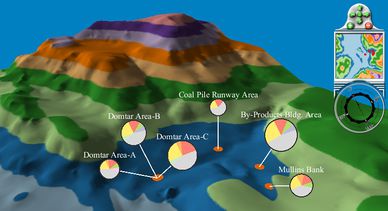
| + | [[Image:SydneyTarPonds.jpg|thumb|388px|right|Abundance of different taxa at sample sites from the Sydney Tar Ponds (data courtesy of [http://www.plosone.org/article/info%3Adoi%2F10.1371%2Fjournal.pone.0005276 Jeremy Koenig])]] | ||
Currently we support Microsoft Windows XP/Vista/7 and Mac OS X (Intel only). GenGIS is released under the [http://www.gnu.org/licenses/gpl-3.0.txt GNU General Public License version 3]. | Currently we support Microsoft Windows XP/Vista/7 and Mac OS X (Intel only). GenGIS is released under the [http://www.gnu.org/licenses/gpl-3.0.txt GNU General Public License version 3]. | ||
=== Current Release Details === | === Current Release Details === | ||
| − | {| cellpadding="5%" style="border:1px solid #BBB; width: | + | {| cellpadding="5%" style="border:1px solid #BBB; width:400px;" |
|- valign="top" | |- valign="top" | ||
! ''GenGIS Version:'' | ! ''GenGIS Version:'' | ||
| Line 18: | Line 19: | ||
|} | |} | ||
| − | A list of known issues can be found [[Known issues|here]]. | + | A list of known issues can be found [[Known issues|here]]. |
| − | |||
<!-- In case you're wondering why we ship all required dependencies with GenGIS, our motives are twofold: | <!-- In case you're wondering why we ship all required dependencies with GenGIS, our motives are twofold: | ||
| − | |||
# It simplifies the acquisition process, as opposed to many iterations of 'go here - get this'. | # It simplifies the acquisition process, as opposed to many iterations of 'go here - get this'. | ||
# It also allows us to ensure that working combinations of the attached libraries can be used. Conflicts might otherwise arise between wx, Python, RPy2, and R. | # It also allows us to ensure that working combinations of the attached libraries can be used. Conflicts might otherwise arise between wx, Python, RPy2, and R. | ||
| Line 28: | Line 27: | ||
=== Windows Release === | === Windows Release === | ||
| − | + | *[[Media:GenGIS_v2.00_setup.zip|Windows installation package (47 MB)]] (XP/Vista/7) | |
| − | |||
| − | *[[Media:GenGIS_v2.00_setup.zip|Windows installation package (47 MB)]] | ||
=== Mac OS X Release === | === Mac OS X Release === | ||
<!--*[[Media:GenGIS_v1_08_OSX.zip|Mac OS X installation package (72 MB)]]--> | <!--*[[Media:GenGIS_v1_08_OSX.zip|Mac OS X installation package (72 MB)]]--> | ||
| − | * Mac OS X installation package | + | * Mac OS X installation package (10.5-7) |
| − | |||
| − | |||
=== MapMaker === | === MapMaker === | ||
Revision as of 16:31, 28 March 2012

Abundance of different taxa at sample sites from the Sydney Tar Ponds (data courtesy of Jeremy Koenig)
Currently we support Microsoft Windows XP/Vista/7 and Mac OS X (Intel only). GenGIS is released under the GNU General Public License version 3.
Contents
Current Release Details
| GenGIS Version: | 2.0.0 (March 29, 2012) (Revision History) |
|---|---|
| Python Version: | |
| RPy2 Version: | |
| wxWidgets Version: | 2.8.9 |
A list of known issues can be found here.
Windows Release
- Windows installation package (47 MB) (XP/Vista/7)
Mac OS X Release
- Mac OS X installation package (10.5-7)
MapMaker
- Download MapMaker to obtain maps compatible with GenGIS.
Sample Data
Sample data can be found on the Tutorials page.
Digital Maps
You can use our tool MapMaker to generate high-resolution GeoTIFF for any region in the world. Instruction on obtaining digital terrain maps (DEMs) are provided on the Tutorials page. We have also assembled a collection of example digital terrain maps:
- Sample world map (GeoTIFF, from GTOPO30)
- Africa (GeoTIFF, from GTOPO30)
- Europe (ASCII grid, from GTOPO30)
- South Pacific (ASCII grid, from GTOPO30, spanning example with longitude 0-360)
- South Pacific Reduced (ASCII grid, from GTOPO30, spanning example with longitude 0-360)
GenGIS Source Code
Source code is for v2.00. GenGIS dependencies are given in /src/Readme.txt.
- Source code package